Thursday, February 26, 2015

Centro Histórico: The Zócalo, Symbolic Heart of Mexico City and Mexico

The core of Delegación Cuauhtémoc, and of the city, is colonia Centro and at its core is The Zócalo. Its official name is Plaza de la Constitución. Literally, zócalo means pedestal, as of a statue, but it has come to mean this space at the center of Mexico.

The Zócalo, with the Metropolitan Cathedral to the north
Photo: JRB

The plaza is set within a massive frame, consisting of the Catedral Metropolitano on the north, the Palacio Nacional on the east, city govenment buildings on the south and hotels on the west.


Palacio Nacional
Photo: JRB


Zócalo in the 18th Century
El Parián market, in the center, built in 1703,
the first covered market in Mexico City

Note the canal to the right.
Painting in the Museum of Mexico City.


Zócalo in the 1930's
Looking south from Cathedral to Ave. 20th de Noviembre
Photo in entrance to Zócalo Metro Station

Photo: JRB

What was once a market place and later a park-like plaza is now la plancha, a flat, paved open space occupied only by a huge flagpole bearing a huge Mexican flag. Like an empty stage, it calls to be filled with actors and drama. It often is.


Christmas in the Zocalo
The line of people are waiting to get into the skating rink.
CDMX is the new logo for the now-official name CiuDad de MéXico - City of Mexico

The government of Mexico City (the federal government recently changed its legal name and status from being the Distrito Federal, Federal District) often stages huge public festivals. During Navidad - Tres Reyes (Christmas to Three Kings Day, Jan. 6), a three to four week holiday period, it sets up an ice skating rink, artificially snow-covered sledding runs and a gigantic artificial Christmas tree, a kind of Rockefeller Center South. A couple of years ago, Paul McCartney gave a free concert to tens of thousands.

Recently, for Valentines Day, which is a much bigger deal in Mexico than the U.S., the city government set up a huge stage in front of the cathedral where a series of bands played and then the Head of Government, aka. "mayor", Miguel Ángel Mancera officiated at a mass wedding for 1,690 couples of every sexual persuasion. Gay marriage is legal in Mexico City. Yes, in front of the Cathedral!

  
The Palacio Nacional has been the center of Mexico's government ever since the Spanish Virreinato (Viceroyalty), so it is the place where el gobierno, the government, and el pueblo, the people come face to face, sometimes peacefully, sometimes not.

On the night of September 15, the beginning of Día de la Independencia, Independence Day, the plaza is filled for "El Grito", the Shout of Independence, in which the president, from the center balcony of El Palacio, re-enacts Father Miguel Hidalgo's 1810 call for a popular revolt against the Spanish viceroy (not the king).

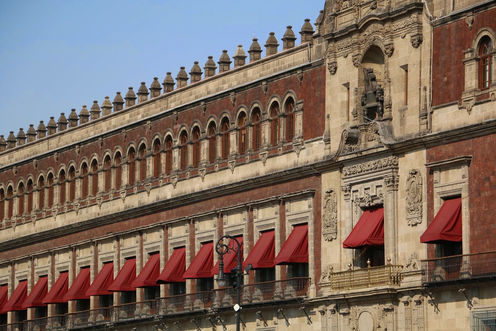
The Presidential balcony is to the right. Above is the bell he rings after he repeats the Shout for Independence

El pueblo, the people, consider the Zócalo to be el corazón del país, the heart of the country, and that it belongs to them, not the government. So it is often claimed by them, that is by popular organizations, and filled with mass demonstrations protesting a multiplicity of issues. These can be rallies at the end of marches through the streets, or even campamentos (encampments) of small tents and lonas (tarps) which can last for weeks and even months. 

While demonstrations continue to occur, since September 2013, when a campamento of dissident teachers was forceably removed by police just before the celebration of Día de la Independencia  (Independence Day) on Sept. 15-16, no others have been allowed. Vamos a ver qué va a pasar. We'll see what's going to happen.

For a recent Mexican view of the symbolic political importance of the Zócalo to the Mexican people, see: The Zocalo Belongs to the People (La Jornada, June 27, 2016)

Tuesday, February 24, 2015

Mexico City Metro: Pathways to Many Stories

The Mexico City Metro (officially, the Collective Transportation System) is a network of subway and surface electric train lines that enables chilangos (city residents' name for themselves) and visitors to get around the city cheaply, quickly and safely.

In 2014, the fare was raised from tres, 3, pesos (less than $.25US) to cinco, 5, pesos (to $.35US at  exchange rate at that time), a 2/3rds increase. This was steep for working class chilangos, but not a problem for extranjeros (foreigners) like us. (The New York City subway is currently $2.50. We remember when it was $.20)

Salida, Exit
So, the Metro is our pathway to many of the city's sixteen delegaciones (boroughs) and their colonias (neighborhoods) with their many historias, their stories.

The system has 12 lines, Lines 1 to 9, A and B, and a new line 12. Each is distinguished by a color in its signage.

Image result for ciudad de mexico metro mapa

We live near Estacion General Anaya, the next to last stop going south on Line 2, the Blue Line (bottom, center of map). Our station is named after General Pedro María de Anaya, who led the Mexican Army in the Battle of Churubusco, on August 20,1847, against the U.S. Army to try to prevent its entrance into Mexico City. The battle occurred at the Ex-convento Churubusco, a fortress-like complex just west of the present station. Its location was strategic, as in controlled the road north to the center of the city. 
Battle of Churubusco, Aug. 20, 1847
That road was originally an Aztec/Mexica causeway, cuepotli, called Xolac, running from the southwest lake shore near Coyoacán. Today it is the eight-lane Calzada de Tlalpan. Line 2 runs along the middle of this highway, straight to the heart of both the Aztec/Mexica (Me-SHE-kah) and modern city, The Zócalo (center of map, just before the Blue Line turns west, following a second original causeway to Tacubaya).

A Line 2, Blue Line, train heads south
down the middle of the Calzada de Tlalpan, from Estación General Anaya
One station is Xola, after the original name of the Aztec/Mexico causeway. Other names often relate to the colonia (neighborhood) in which they are located, such as Ermita, Portales, Nativítas or Villa Cortés. Others indicate a major cross highway, such as Viaducto, a major nearby institution (Bellas Arteson Line 2 west of The Zócalo. Hospital General is a stop on Line 3, the Olive Line) Revolución, west of Bellas Artes on Line 2, is near the Monument to the Revolution.


The stations have clear signage directing you to the platform (Andenes) and, on the platform, telling you which direction a train is traveling, that is, the name of the last station in that dirección. Heading north on Line 2, we go towards Cuatro Caminos (Four Ways, the four cardinal directions of the indigenous world). Heading home, we follow the sign for Tasqueña, which is also the location of the South Bus Station, where one gets buses to Cuernavaca and Acapulco.


Trains, at least on Line 2, are quite new and clean. They run on rubber tires, so they are quiet.


The rides, themselves, are an immersion in Mexican culture. In Mexico, wherever people gather, a market is created. On the Metro, this means vagoneros, vendors who walk through the cars hawking all kinds of products: CDs (which are loudly played through speakers strapped to the vendor's back), chicklets, cell phone earphones, books, you name it, almost always for diez (10) pesos ($.70US).


In 2014, the Distrito Federal (aka. De.Fe., Federal District) government initiated a campaign to get them off the trains. They offered to pay them the minimum wage (US$5 per day) for up to six months while training them for other jobs. In typical Mexican style, it didn´t work and they were soon back on the trains.

Various stations are interchanges between two or more lines. Good signage again directs you to the correspondencia, the connecting line.


So get your cinco pesos out of your monedero, coin purse, buy a boleto, ticket, at the taquilla, ticket window, and ¡vámanos! Let's go!

Saturday, February 21, 2015

Mexico City Delegaciones: Sixteen Puzzle Pieces

Mexico City is shaped rather like a lumpy pear. Skinny at the top, it even has a "stem", then rounds out into a very fat bottom. It is divided into sixteen delegaciones, or boroughs, of greatly varying sizes, shapes, population densities and histories.

Mexico City's sixteen delegaciones (boroughs)

The Historic Center of the city is in the northern, skinny part, in the delegación of Cuauhtémoc. It is where the Mexica/Aztec city of Tenochtitlán was located on an island in the middle of Lake Texcoco. Other indigenous city-states or altepetls lined the lake shore, including Azcapotzalco, Tlacopan, Coyoacán, Culhuacan and Xochimilco.


Tenochtitlán, with Templo Mayor
Volcanoes Iztaccíhuatl and Popocatépetl form the eastern horizon

Painting in Museum of the City of Mexico

In 1521, after Hernán Cortés and his indigenous allies defeated the Aztecs, the Spanish leveled the indigenous city and began constructing Mexico City. 

"House of the Blue Tiles",
in Centro Histórico.
Palace built in late 1700's
by the Count del Valle de Orizaba
Although the Spanish soon began draining the lakes to reduce flooding in the summer rainy season, the city remained pretty much confined to the island until the 20th century. 

The other indigenous towns were developed as separate Spanish colonial towns, where the wealthy peninsulares (born in Spain) and criollos (Spanish born in the New World) established country homes and haciendas, rather like the estates built by Boston Brahmins on Newport Island and in the Berkshires, and wealthy New Yorkers built along the Hudson. 

Valley of Mexico, mid-19th century, by José María Velasco
Mexico City lies in the distance, middle left.
Volcanoes Iztaccíhuatl and Popocatépetl form the eastern horizon.


In the 19th and 20th centuries, the Federal Government gradually incorporated the outlying towns and the surrounding mountains to the south and west into what was then known as the Federal District [January 2016, Mexico City officially became its own governmental entity]. 

During the Porfiriato, the continuous presidency of Porfirio Díaz from 1876 to 1911, stylish suburban colonias or neighborhoods of large homes, such as Santa María RiberaSan Rafael and Roma were built for the new, wealthy industrial and commercial class on drained lake bed to the west and south of the city center. After the Mexican Revolution, in the 1920's and 1930's, additional neighborhoods, like Condesa were developed. Not until after World War II did the city´s growth explode—ingesting, amoeba-like—all these outlying settlements.

Thus, contemporary Mexico City is an amalgam, a crazy quilt or a collage of barrios and colonias from many centuries and cultural epochs, with their varying architectural styles. Some, such as Azcapotzalco, Iztacalco, Iztapalapa, Coyoacán, Tlalpan, Xochimilco and Tláhuac, as indicated by their indigenous names, have historic cores going back more than seven centuries, and some buildings, often Spanish colonial churches, that go back four or five.

San Juan Bautista, St. John the Baptist church,
in Coyoacán
built by Franciscan monks in the 1520's.


Others, including the colonias of Santa Maria Ribera, San Rafael, and Roma in Delegación Cuauhtémoc, are Parisian-style enclaves from the turn-of-the-19th to 20th century. 

Palacial home in Roma Norte
converted to apartments


Yet other delegaciones, like Benito Juárez, which fills part of the old lake bed, or Miguel Hidalgo and Álvaro Obregon that expand to the northwest and southwest, are Post-War modern. 

Modern home in Benito Juárez


And in the plains and mountains to the south and west, in the delegaciones of Tlalpan, Milpa Alta, Tláhuac, Xochimilco, Magdalena Contreras and Cuajimalpa, there are pueblos (traditional villages) where nopal cactus, vegetables and flowers are grown to supply "the city", where men wear cowboy hats and ride horses, and patron saint fiestas are celebrated as they are in "las provincias" (the other states), just as they have been since Spanish Catholicism was merged with indigenous religions.


"Chinelo" dancers, from the Nahuatl word “zineloquie”, “disguised"
The costumes reflect the Moors, driven out of Spain.
Dances of the Moors were brought by Spanish friars to Colonial Nueva España
to show the indigenous "heathen" the need to convert to Catholicism,
but they were turned by the indigenous into means for mocking the Spanish.
Candelaria Fiesta (Feb. 2, mid-winter)
in the pueblo of Santa Maria Magdelena Petlacalco,
on the side of Ajusco Mountain
in Delegación Tlalpan

It is interesting to note the two sets of names used to identify delegaciones: nahuatl (Aztec) for those with roots in native histories, in contrast with those named after the leaders of Mexico's development as an independent nation. This distinction reflects a three-way divide between Mexico's indigenous culture, Spanish colonial culture and alternating post-Independence efforts to distance from these conflictual pasts or try to synthesize them into a national "Mexican" identity.

This struggle is embodied in the name of delegación Magdalena Contreras, located in the "rural" western mountains. Combining the Spanish name of an indigenous pueblo, Magdalena Atlitic, with Contreras, a 20th century colonia of textile mills is one divide, but the double name, Magdalena Atlitic, presents another. Throughout Nueva España, as part of their intentional acculturation of the natives, Spanish friars gave Catholic saint names to the extant indigenous villages. Most retain these double names and identities; hence, Magdalena is the Spanish name, Atlitic is the Nahua.

Mexico City Ambles is a record of paseos, leisurely walks, spent exploring some of the colonias in this urban-rural, multi-cultural collage.