Friday, December 23, 2016

Mexico City's Original Villages | Miguel Hidalgo: Tacuba and The Roadway Where History Took a Fateful Turn

The Historic Roadway from Tenochtitlán to Tacuba


We began our series of ambles seeking out the Landmarks of the Spiritual Conquest, which identify the original indigenous villages from which Spanish Mexico City arose, by exploring what were the Four Original Indigenous Quarters of Tenochtitlán, now Centro. Cortés assigned them to his indigenous allies who had made the conquest of Tenochtitlán possible. Together, these four quarters were called San Juan Tenochtitlán.

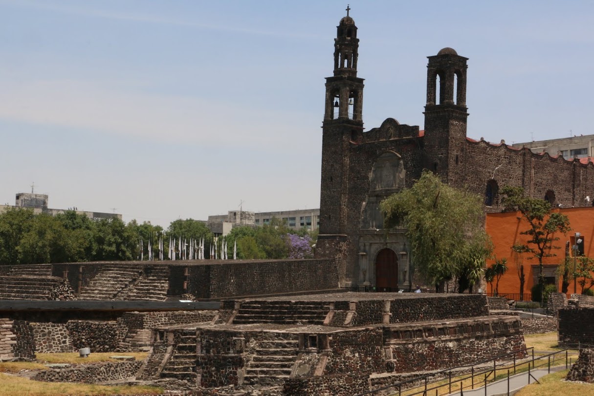
When we explored the northwest quarter, Santa María Cuepopan, we discovered that the Church of San Hipólito stands at a most significant place in the history of the tumultuous change of Tenochtitlán to la Ciudad de México. It was here that Cortés and his men, attempting to flee Tenochtitlán on the night of June 30, 1520, were confronted by Mexica [meh-SHE-kuh] warriors.

San Hipólito sits at the intersection of Avenida Hidalgo,
which, to the west, becomes the Calzada México-Tacuba,
Ave. Balderas, which marks the western boundary of former Tenochtitlán,
and Paseo de la Reforma.


Night of Sorrows


On May 20, while Cortés was in Veracruz on the Gulf Coast, the Spanish had massacred Mexica priests at the Templo Mayor, then on June 26, the huey tlatoani (head speaker) Moctezuma Xocoyotzin (Moctezuma the Younger) had been killed in a confrontation between his Spanish captors and his own people. Cortés and his men were surrounded in the royal palace. In the dark of the night of June 30, they attempted to sneak out of the city.

Not surprisingly, they were caught in the act. Mexica warriors confronted them at the point where the roadway from Tenochtitlan to the important atepetl, city-state, of Tlacopan, on the west shore of Lake Texcoco, reached a moveable bridge and entered the causeway across the lake.

The Night of Sorrows - Library of Congress; Artist Unknown
Noche Triste, Night of Sorrows,
Artist unknown

Noche Triste
José Clemente Orozco

Tlacopan (now Tacuba)
was located on the west side of Lake Texcoco.
At the time of the arrival of the Mexicas in the Valley of Anahuac,
it was under the rule of A(t)zcapotzalco, just to their north.

On that fateful night, Cortés and his surviving troops, with the help of indigenous allies, managed to reach the western shore. It is legend that Cortés then collapsed beneath an ahuehuete tree and wept over his lost men. Ahuehuete means "old man of the waters" in Nahuatl. The trees, sacred to the indigenous, now carry the name Montezuma cypress.

All that remains of the trunk of the ahuehuete tree,
below which Cortés is said to have wept on the Noche Triste,
June 30-July 1, 1520.
The tree remained alive until the early 20th century.
Another Montezuma cypress,
planted some years ago, rises behind it.


The tree sits in a small plaza,

alongside the Calzada México-Tacuba,
about half way between Metro Stations Popotla and Cuitláhuac

Noche Triste
Cortés and his troops rest
on the lake shore at Tlacopan
José Clemente Orozco

Today that causeway is a major avenue, bearing several names as it extends west. Just west of San Hipólito, it is called Puente de Alvarado, Alvarado's Bridge, named after a lieutenant of Cortés who was thought to have been lost at the bridge. Subsequently, he made it to Tlacopan. The primary name of the street is the Calzada (literally, "footpath") México-TacubaLine 2, the Blue Line, of the Metro follows this ancient roadway from the Zócalo to Tacuba and beyond. So you can get there in about 15 minutes, for 5 pesos, US $0.25.

Tlacopan


The name of Tlacopan (place of the jarilla plant—same family as papaya) was converted by the Spanish into Tacuba. It is now a colonia in Delegación Miguel Hidalgo. When Cortés arrived in the Valley of Anahuac in 1519, its people were Nahuatl speaking Tepaneca. A hundred years earlier, it had been under the rule of the Tepanec atepetl of Azcapotzalco, just to its north.

However, in 1428, when the ruler of Azcapotzalco died and a power struggle erupted between possible replacements, Tenochtitlán and Texcoco, an atepetl on the east side of the Lake, decided it was their opportunity to ally against the city that dominated them. Tlacopan joined them against its overlords, thus becoming the third member of the Triple Alliance, which was to rule what is now Central Mexico for nearly one hundred years, until the arrival of the Spanish in 1519.

Tlacopan's importance led the Mexica to construct the causeway over the lake linking it with Tenochtitlán.  When Cortés and his surviving soldiers arrived via that causway to Tlacopan on July 1, 1520, in flight from Tenochtitlán, the rulers of Tlacopan rather than siding with their Mexica allies, chose instead to give shelter to the Spanish. They thereby opened the way for Cortés' retreat around the north end of the lakes and his return to Tlaxcala, the home of his major indigenous ally, over the mountains, east of the Valley.

There, Cortés was able to restore his troops and plan his ultimate attack on Tenochtitlán in the spring and summer of 1521. After the Spanish defeat of the Mexica in August of that year, Cortés granted Tlacopan/Tacuba to Isabel Moctezuma, a daughter of Moctezuma Xocoyotzin. In the first decades of the Colonial period, the village continued to be governed, for local purposes, by indigenous nobles, to whom Spanish names were given upon their baptism. One was Don Diego Cortés Chimalpopoca; another was Don Antonio Cortés Totoquihuaztli. The conqueror certainly left his mark.

Cortés. his soldiers and indigenous allies
defeat the Mexica of Tenochtitlan

Church of San Gabriel the Archangel


As they did in other cities and villages around the lakes of the Valley, the Franciscans came to Tlaopan, which they called Tacuba, built a mission church and dedicated it to the Archangel Gabriel who had announced to the Virgin Mary her pregnancy with the Son of God. The church was consecrated in 1566. In 1570, a convent or monastery was built and occupied by four friars, charged with converting and educating the people.

Church of San Gabriel Archangel, Tacuba

The site was within the prior sacred precinct of Tlacopan. The indigenous teocalli, house of god, was located on a low hill to the west of where the church was erected. In addition to stone quarried nearby, stones from the teocalli were used in building the church,

It served some fifteen settlements in the area. Like other convents, it had an orchard where figs, grapes, pears, apples, peaches, apricots and nuts were grown. It was significantly remodeled in the mid-18th century when the Archbishop of México took over the churches of the religious orders and made them parochial ones. Its original rectangular shape was enlarged into a cross.

Landmarks of the Conquest


While the church originally sat on the west side of a large plaza, it now sits in the midst of a sea of puestos, commercial stalls. Hence, getting to the building on a Sunday morning involves wending our way through a labyrinth of merchandise and foodstands.

As we have noted in our introduction to the Landmarks of the Spiritual Conquest, there are four primary such landmarks to identify an Original Indigenous Village: a church built in the early years of Nueva España, a government building, and a market—all centered around a plaza. One or another may be missing, most often a government building, as Mexico City´s government of neighborhoods has been centralized in the delegaciones, boroughs.

Former City Hall, in 1920s.
It and a glorietta, traffic circle,
have been replaced by the mercado
.
Photo: Wikipedia en español

Here in Tacuba, we learn that the former city hall, which governed the area before it was incorporated into Mexico City in the 1920s, was demolished in the 1960s. Initially, a plaza was recreated, but it has been taken over by a semi-formal mercado. What thus remains is a kind of face-to-face standoff between market and church.

Semi-permanent puestos, stalls have been erected
in what was once a plaza in front of San Gabriel.
Many of the trees remain.
The street is the Calzada México-Tacuba,
which runs to Centro Histórico, following the Mexica causeway.

Mexican menu (hanging above): 
Tacos are soft tortillas, folded and filled with various ingredients.
Huaraches are thick, long "sandal-shaped" tortillas covered with ingredients.
Gorditas are thick, round tortillas stuffed with ingredients.
Tostadas are thin, flat, crisp-fried tortillas 
covered with ingredients.

Entrance to the church atrio,
from the mercado, market

Main entrance
The overall simplicity reminds us of other Franciscan churches.
The stone portal is from the Baroque renovation in the mid-18th century.

Bas relief portraying the Annunciation to the Virgin Mary by the Archangel Gabriel
of her pregnancy with the Son of God
(Note the baby descending from God the Father in Heaven)

The sculpture is in Baroque style, added in the 18th century reconstruction.
At lower left is the date 1733, which may have been cut over an earlier date of 1573.

Main altar, from the Baroque period.
The spiral columns are "solomonic",
a style derived from ancient Greek columns 

incorporated into St. Peters Basilica.
(See our: California Colonial: From Emperor Constantine to Mexico via Spanish Baroque)
and Mexico Barroco

Oratorio, Prayer chapel
in the former convent,
to one side of the main sanctuary.

Church and Monastery of San Joaquín


About a mile southwest of San Gabriel and the center of Tacuba, down the wide, tree-lined Calzada de Legaria, is the Panteón Francés de San Joaquín, the French Cemetery of San Joaquín created in the 1940s.

Until the mid-19th century, when the Reform government of Benito Juárez seized much church property to try to eliminate the wealth and power of the Catholic Church, its many acres were the orchard of the Church and Convent of San Joaquín. It sat beside a river the Spanish also named San Joaquín, which flowed from the mountains to the northwest into Lake Texcoco. Like virtually all the rivers of the Valley of Mexico, it is now "entubed" and runs under Ave. San Joaquín, which passes by the south side of the cemetery. 

What remains of the complex, the church and part of the convent, sit in the northwest corner of the Panteón, behind a high wall. To find it, we have to walk from the current entrance to the Panteón on Legaria, around a corner past a children's hospítal, also on the former orchard grounds, and along narrow Calle Santa Cruz Cacalco bordered by the high stone wall enclosing the cemetery. Coming to a small, triangular plazuela, we find a small door open in the wall.

Church of San Joaquin

Stepping inside, we find ourselves in another of those marvelous oases of Spanish colonial tranquility. The church atrio is geometrically formal, with straight stone walkways crossing it at right angles, but softened by trees and some flowering plants in the squares between them. The church itself is constructed of stone and very rectangular.

Doors in the Atrio wall, leading to the street.
Only the small doors were open where we entered.

The Church and Monastery were built by the Carmelites in 1689. It was the eleventh Carmelite convent in Mexico. They had previously developed the Convent of San Ángel, now in the colonia of that name in Delegación Álvaro Obregon, which we have already visited. The San Ángel Church, like many churches in Mexico, was redone in the 18th century in florid Baroque style. Not so San Joaquín. It retains it orginal spare, almost severe, monastic simplicity.

Side door to the sanctuary.

As we hoped, on this Sunday morning, mass is being celebrated, so the church is open.


The interior is as spare as the exterior, all unplastered stone. The ceiling is also stone, but the dome is brick. Personally, perhaps because of our Protestant background, and maybe because of memories from long-ago visits to medieval Gothic cathedrals in Europe, we find the space very attractive, tranquil, conducive to meditation. 

Where Architectural Beauty Flows From Functional Demands


Mass is soon over, so after the parishioners leave, we go inside to examine the architecture more closely.

The Nave is covered by two intersecting barrel vaults,
forming a groin vault.

Piece de resistance:
To us, the dome, with its contrasting circles of black and red brick,
is a masterpiece of beauty created out of functional demands.

Enticed to See More and Invited to Return


As we are photographing and savoring the church's classic structure, we notice that a group of muscians who were playing for the mass are putting away their instruments in one side of the transept that crosses the nave below the dome. We greet them and comment on the unusual and strikingly simple aesthetic, so in contrast to Mexico City's predominantly Baroque churches, and we explain our mission of exploring and creating blog posts on those original churches and villages.

A woman, probably in her late forties, responds and asks if we would like to see the convent which is beside the church. This is beyond our expectations! We are delighted and express our appreciation for the offer. She leads us through a door in the transept. 

We enter what is clearly an old passageway, wide, with a high, beamed ceiling. We raise our camera, but she tells us that photos are not allowed. We have run into this invisible but unyielding barrier many times before in old Mexican buildings. Although we know from those past experiences that it will do no good, we ask,
"¿Por qúe?", "Why?" 
"Porque es patrimonio del país," she replies. "It is the patrimony of the country." 
Since she seems friendly and open, we venture to express that it seems a contradiction that what is explicitly being preserved as national heritage so it can be experienced by succeding generations of both citizens and foreigners is off-limits to photos, which are a means of sharing this richness with others who otherwise might never experience it. And it might even entice them to pay a visit. She nods in agreement.

She tells me that guided tours are given once a month, but she doesn't know the date. She offers to go find the priest to ask, and maybe, she implies, he might give an okay for me to take some photos. As we walk down the hallway, we pass an open door. She tells us that is the garden—that in fact, there are two gardens, but we cannot enter, as the church is about to be closed. 

We go in search of the priest, but discover he has already left. As we leave the atrio, our guide speaks to another of the musicians. He knows the phone number of the priest and writes it down for us. If we call, we can find out when the monthly tour takes place. And, maybe, we can get permission to take some photos. We hand the two musicians our card: "Mexico City Ambles, Paseos por la Ciudad de México", with our web address and email. 

Once again, our amble has led to wonderful surprises: an architectural and historical gem and still other muy amable mexicanas y mexicanos, very kind Mexican women and men who want to share those gems with us. We tell them that we certainly hope to be able to return to see the convent. After all, not only are we photographers and amateur historians of Mexico. We are also gardeners and the orchard of San Joaquín still exists, if only in cloistered, miniature form.

Delegación Miguel Hidalgo (brown)
is in the northwest section of the City,
It is just west of Delegación Cuauhtémoc,
location of Centro and former Tenochtitlan.

Delegación Miguel Hidalgo
Tacuba and San Gabriel Archangel are marked by green star, top center.
Church and Convent of San Joaquin
are marked by orange star,
to left, west

Much of the lower part of Miguel Hidalgo
is occupied by Chapultepec Woods
(dark green area).

Just to the west is the State of Mexico.
See also:

Saturday, November 26, 2016

Mexico City's Original Villages | Tlatelolco: Where Empires Clashed

When Hernán Cortés and his Spanish troops arrived in the Valley of Anáhuac (now the Valley of Mexico) in 1519, Tlatelolco was essentially merged with Tenochtitlan. Its excavated remains are located two kilometers (about a mile) north of Tenochtitlán (now represented by the remains of the Templo Mayor, in Centro Histórico).

Tlatelolco had been founded in 1337, by a group of dissident Mexica who broke away from the leadership of Tenochtitlan, which had been founded only twelve years earlier, in 1325. They established Tlatelolco on another island just north of Tenochtitlan. Both cities were subject to the dominant altepetl on the west shore of the lake, Azcapotzalco. About one hundred years later, in 1428, Tlatelolco joined Tenochtitlan, along with two other atlepetls, Tlacopan and Texcoco, in overthrowing the rulers of Azcapotzalco. Tenochtitlan became the dominant power all the area around Lake Texcoco and then the entire Valley and beyond.

After nearly fifty years of more or less peaceful coexistence as physically and ethnically close neighbors, in 1473, Tenochtitlan, having become the power controlling all of what is now south-central Mexico, attacked Tlateloloco and took it over, subsuming it into their city.

Today. Tlatelolco is surrounded by modern apartment buildings and major boulevards. We might have taken Metro Line 3 to get there, but we chose a taxi instead.

Mexica temples of Tlatelolco (14th century) stand in front of Church of Santiago, St. James.
The Franciscans first built a "hermitage", a small chapel. 

It was replaced by a larger church in 1545 and enlarged further in 1609.
Convent stands to the right.

(See: Portraying Mexico City's Azteca/Mexica Origins)

A Center of the Spiritual Conquest

After the Spanish conquered the Mexica in August, 1521, they immediately razed to the ground all the temples and pyramids of Tenochtitlan and Tlatelolco. They claimed the center of Tenochitilan for themselves and built their own temples and palaces above the ruins. Tlatelolco was assigned as a barrio for the defeated Mexicas. In the early 1530s, the Franciscans, who had been sent from Spain to convert the native population to Catholicism, soon built a church and convent (monastery) at the sacred and now culturally and politically crucial site.

The convent was established as the Imperial College of the Holy Cross, a school to educate the sons of Aztec noblemen in Spanish culture and train them for the priesthood, a core strategy of the Spiritual Conquest, to convert indigenous religious beliefs and culture into a Spanish Catholic one. According to legend, it was to this convent that Juan Diego, an indigenous convert, was headed in December 1531, from Tepeyac, on the northern shore of Lake Texcoco, when he was confronted by a vision of the Virgin of Guadalupe, the quintessential representative of the Spiritual Conquest.

It is telling that when the indigenous students began surpassing their Spanish teachers, the Spanish king and Church hierarchy found ways to restrict the curriculum. Eventually, they closed the school entirely.

Interior patio of the Franciscan convent, 
Imperial College of the Holy Cross

The convent also became a center for the study of Mesoamerican cultures. It was here that the Franciscan priest Bernardo de Sahagún wrote his History of the Things of New Spain, the seminal work on Aztec culture that remains a highly regarded source text.

Contemporary Plaza of Three Cultures

In recent times Tlatelolco was renamed Plaza de las Tres Culturas (Plaza of Three Cultures) because the structures there give living testimony to the cross-cultural process that created mestizaje, racial mixing, in Mexico. Most Mexicans regard themselves as mestizo, as having both indigenous and Spanish ancestors.

The ruins of the original center of Tlatelolco are dwarfed, on their south side, by a modern office tower that formerly housed the Secretariat of Foreign Relations, but today is occupied by a campus of UNAM (National Autonomous University of Mexico). On the east side sits the Church and Convent of Santiago Tlatelolco, the colonial hinge between the country's Mexica-Aztec heritage and today's Republic of Mexico.

The plaza at Tlatelolco has been the setting of three tragic events in Mexican history, one ancient and two modern, making it a symbolic place of much emotional power:
  • August 13, 1521: After their defeat at Tenochtitlán, the Mexicas fled to Tlatelolco where they again faced the Spanish and their indigenous allies seeking to overthrow Mexica domination; overrun, the Mexicas, led by huey tlatoani, "head speaker" Cuauhtémoc, surrendered; 
  • October 2, 1968: Just before the opening of the Summer Olympics in Mexico City, the Mexican Army opened fire on a student demonstration, killing hundreds of students; 
  • September 19, 1985: major earthquake (7.8 Richter) shook Mexico City; several Tlatelolco high-rise apartment buildings, built in the 1970s, collapsed like accordions—the tragic consequence of builders who had lined their pockets by taking shortcuts with building materials and methods; the death toll was in the thousands.
Sign reads:

"On August 13, 1521, 

heroically defended by Cuauhtémoc, 
Tlateloloco fell under the power of Hernán Cortés.
Neither a triumph nor defeat; 
it was the painful birth of the mestizo people
that is Mexico today."
Source: Eduardo Aguilar-Moreno, Aztec Architecture;
Photo: Fernando González y González.

A Short History of Tlatelolco


Tlatelolco lay about one mile north
of its sister Mexica atepetl of Tenochtitlán,
originally on a separate island.
After the Tenochtecas defeated the Tlatelolcas in 1473, 

it was politically and physically joined to Tenochtitlán.

Like Tenochtitlán, Tlatelolco was built on a muddy island in Lake Texcoco. In the middle of the 14th century A.D., a group of Mexicas split off from the main tribe who had founded Tenochtitlán in 1325.
The dissidents didn't go far. They established their new community about a mile north of their home city and named it Tlatelolco—some scholars assert that the name derives from the word tlatelli, meaning 'built-up mound of earth'. And, after all, they were still Mexicas. So it's not surprising that their founding myth parallels Tenochtitlán's:
...a whirlwind had led them to an island with a sandy mound upon which rested a round shield, an arrow, and an eagle—strongly reminiscent of Tenochtitlán's cactus, eagle, and snake.
They petitioned Tezozómoc, the tlatoani, chief speaker of Aztcapotzalco, a Tepanec atepetl on the west side of the lake, for a king who would link them to the historic dynasties of central Mexico. From Aztcapotzalco, the Tepanec, another Nahuatl speaking group, controlled the west side of Lake Texcoco. Tezozómoc gave them his son, Cuacuapitzáhuac, who was also kin to Tenochtitlán's dynastic clan [Andrew Coe, Archaeological Mexico, p. 86].

Under their new ruler, Tlatelolco became part of the Valley of Mexico's intricate network of tribute relationships. In return for its protection, its rulers had to pay tribute to Aztcapotzalco in both staples and luxury goods. The Tlatelolcans also had to fight for Aztcapotzalco against its rivals.

Tlatelolco Finds Its Niche: Trade and Tribute


Tenochtitlán was Tlatelolco's major rival. Fortunately, Cuacuapitzáhuac cannily identified an empty niche: trade. He established the first large-scale market and instituted what would become the Tlatelolcan tradition of pochtecas, or long-range merchants.
At first, the pochtecas confined their trips to the Valley of Anáhuac (now Valley of Mexico), but eventually they ranged to the very edges of Mesoamerica: east to the Gulf of Mexico (Veracruz); west to the Pacific Ocean; south to Oaxaca and Chiapas—even as far as present-day Guatemala and Honduras; and north as far as the deserts inhabited by the "Chichimeca" ("barbarian", hunter-gatherer) tribes. Not only did the pochtecas learn the language and customs of foreign tribes, but they often acted as spies by collecting strategic information in advance of the Mexica-Aztec army.
Eventually, Tlatelolco's pochtecas controlled long-distance trade in the luxury goods (quetzal feathers, turquoise) deemed essential for Mexica political and religious life. After the Mexica-Aztecs and their allies of Texcoco and Tacubaya defeated their principle rival, the Tepanecs of Aztcapotzalco, the Aztec hegemony spread throughout central Mexico spearheaded by Tenochtitlán warriors and Tlatelolco merchants, who established trade routes from newly conquered peoples back to the Valley of Mexico.
Cuacuapitzáhuac's son Tlacatéotl moved the city market into a large plaza near the main ceremonial center. At its new location, the market soon became the hub of an extensive trade network; quite probably, it was the largest market in the Americas prior to the arrival of the Spanish.

The level of activity in the market strains credulity. Every day, as many as 20,000 vendors and market-goers crowded into the market square. Every five days, it is estimated that closer to 50,000 or even 60,000 people passed through the market!

The stalls were similar to those seen on Mexican streets today—mats covered by fabric shades for protection against sun and rain. Vendors were of two types, artesans bringing the labor of their own hands and merchants bringing wares from outside the city.

There was no money as such. Exchanges were arranged either by trueque (barter), or by using cacao seeds or salt as the medium of exchange. The Tlaltelolco market also had a tecpan, or house of judges, that resolved disputes and dealt with robberies, or whatever other issues that might arise. Punishments were severe and swift. The punishment for robbery was mandatory death by stoning.

Tlatelolco Loses Its Independence


In the 1420s, the Tenochtecas formed their famous Triple Alliance with the the Tepanec atepetl of Tlacopan, just south of Aztcapotzalco, and the atepetl of Texcoco, developed by the originally Otomí-speaking Acolhua people on the east side of the Lake. Together, they defeated Aztcapotzalco and took control of its tributary atepetls and villages. Tlatelolco remained an independent sister city-state.

However, in 1473, Tlatelolco was taken over by Tenochtitlán and then administered by a military governor. The new arrangement didn't affect the Tlatelolcan merchants, who continued to travel and bring back wares from throughout Mesoamerica. But Tlatelolco did lose important rights as an independent city-state—most significantly, the right to collect tribute and the right to perform important religious rites. In war, Tlatelolco's proud warriors were demoted to porters.

Tlatelolco, however, continued to play an important role for the dominant Tenochtecas. In fact, on Hernán Cortés's first visit to Tenochtitlán, the ruler Moctezuma the Younger took the Spaniards to visit the Tlatelolco market. Bernal Díaz, a soldier with Cortés, later wrote:
"...we were astounded at the great number of people and good quantities of merchandise, and at the orderliness and good arrangements that prevailed, for we had never seen such a thing before."
Taken to the top of Tlatelolco's great pyramid, the Spaniards enjoyed an excellent view of the entire city and the surrounding lake. Díaz wrote:
"We saw [pyramids] and shrines in these cities that looked like gleaming white towers and castles: a marvelous sight."
In the face of the Spanish incursion, Tlatelolco remained loyal to Tenochtitlán. When, in 1521, Hernán Cortés and his soldiers returned to attack Tenochtitlán, along with thousands of warriors from other city-states fed up with harsh Mexica rule, Tlatelolco remained on the side of Tenochtitlán.

Tlatelolco: A Walk Through Space and Time

Serious archaeological work began at Tlatelolco in 1944 and continues to the present day.

Archaeological investigation at Tlatelolco:
Worker cleaning an artifact—Yes, he's using a Q-Tip!

Like other indigenous ceremonial centers in Mexico, Tlatelolco was designed to reflect the Mesoamerican cosmovision. The diagram below shows the layout. The yellow line is the walkway that visitors follow through the site. The site is oriented to the four cardinal directions: visitors enter at the southwest corner; both the Great Temple and the altar of Santiago-Tlatelolco Church face east. The modern office tower rises on the south side (lower right).

Site map of Tlatelolco ceremonial precinct (green) with
Santiago (St. James) church and Franciscan convent (red).

In our amble through the site we pay particular notice to: (1) Temple of Ehécatl-Quetzalcóatl; (3) Tzompantli Altar - south; (4) Temple of the Calendar; (5) Priest's Palace; (7) core Great Temple Pyramid; (8) Successive pyramid walls constructed over time. The unnumbered blue rectangle in front of the convent is the Sacred Well, discussed below.

Temple Of Ehécatl-Quetzalcóatl (1)


The first temple we encounter is one that was dedicated to Ehécatl, the wind deity, who was a manifestation of Quetzalcóatl, the feathered serpent. The temple consisted of a semicircular base that wound into a circular staircase, platform and cone-like roof.

Its entrance was shaped like a snake’s mouth, symbolizing Quetzalcóatl. Construction of this temple dates back to the early times of Tlatelolco. Other structures were subsequently built over it.

Temple of Ehécatl-Quetzalcóatl
Ehécatl is the manifestation of Quetzalcóatl as the wind.

Temples dedicated to Ehécatl, god of wind, are generally of a circular shape to reflect the swirling wind. Since winds come just before the rains, Ehécatl-Quetzalcóatl and Tlaloc (god of water) often appeared together—as they did, for example, at the dual pyramid, Temple of the Feathered Serpent, at Teotihuacán. Here at Tlatelolco, deposed from his primal role at Tlaloc's side, Quezalcóatl was assigned his own, secondary temple space.    

Spiral from the back wall of Great Temple.
Spirals symbolize the whirling winds of Ehécatl-Quetzalcóatl.

Tzompantli Altar - South (3)


This altar is one of two; the other is on the north side of the site.

Tzompantli, site of a wooden skullrack.
White columns in the background belong to office building.
Its construction involved razing some smaller temples on the site.

According to Mary Miller and Karl Taube (The Gods and Symbols of Ancient Mexico and the Maya, p. 176):
"One of the more striking structures of Mesoamerican public architecture was the tzompantli, or skullrack. This was a wooden scaffold containing human skulls pierced horizontally by crossbeams.... 
"In the Quiché Maya popul vuh [story of the origins of the Maya, beginning with Creation], the severed head of the hun hunapu [father of the legendary twins who created  corn and humanity] was hung in a gourd tree next to the ballcourt. This gourd tree is clearly a reference to the tzompantli filled with human skulls. In Nahuatl, the term for head is tzontecomatl, with tecomatl signifying gourd tree. It appears that, like the Sumbanese skull trees of Indonesia, the tzompantli was considered as a tree laden with fruit."

Temple of the Calendar (4)


The next structure that greets us is the Temple of the Calendar. It was an especially significant structure because one of the primary duties of the priests was establishing and maintaining the temporal structure of life and the culture.

The Temple of the Calendar bears the symbols of the Tonalpohualli (divinatory) calendar. The Mexica-Aztecs, as did all the peoples of Mesoamerica, used two calendars:
  • The Xiuhpohualli was the Solar Calendar, which consisted of 360 days divided into eighteen, twenty-day "months"—each month presided over by a god, whose festival was celebrated that month. The Solar Calendar was also used to organize commerce and date the all-important tribute collections. 
  • The Tonalpohualli was the Divinatory Calendar, which consisted of 260 days—possibly based on the human gestation period—created by combining a sequence of twenty day-names with the numbers one to thirteen in rotation. This calendar was used to foretell the fate of individuals based on their date of birth. 
Priests also consulted the Divinatory Calendar in advance of government or family actions to be taken—to wage war, for example, or to celebrate a royal wedding—in order to determine the day's balance of favorable and unfavorable energy. When a date was characterized by unfavorable energy, the energy balance could be ritually addressed to influence a more favorable destiny.
    Temple of the Calendar 

    Representations of day-names, inscribed on three sides, were originally painted in blues, reds and whites. Following are some of the inscriptions of day-names and number combinations. The number is indicated by circles at the margin.

    One-Itzcuintli (One-Dog)


    Two-Tochtli (Two-Rabbit)

    Four-Ollín (Four-Motion, or Life-Force).
    The center of the symbol is a circle 
    representing the axis mundi, world axis, 
    which links the heavenly plane (above) 
    with the earthly plane (horizontal 'bar') 
    and the underworld (below).

    Cuauhtli (Eagle)

    The temple base also had multi-colored paintings with figures that relate to Tlatelolco's history. 

    Priests' Residential Complex (5)


    Each deity in the ceremonial precinct had its own priests, who were housed within the ceremonial precinct. Priests were responsible for maintenance of the temples associated with the cult of the deity to which they belonged.

    The residential structure for the priests consisted of an altar and two sections adjoined by a central corridor with a chimney like area for burning wood.

    Priests' Residential Complex

    Behind (east of) the priests' complex was the sacred well:
    "[It] resembles a ... swimming pool, [with a staircase] that leads to the sacred well...approximately 3 meters [almost 10 feet] wide. Scholars believe it may have been used for ablution practices or as a sacred spring." Eduardo Aguilar-Moreno
    Because of Mesoamericans' dependence on agriculture, water has been a primary concern from earliest times. Oceans, mountains and springs were worshiped as sources of water.

    Tlatelolco's Great Temple (7), (8)


    Tlatelolco's ceremonial complex was dominated by a typical Mexica double pyramid similar to the Great Temple at Tenochtitlán in Centro Histórico:

    Following the walkway, we pass the 'layers' of expansions (8) 
    to Tlatelolco's Great Temple, added by successive rulers. 
    The large rectangular platform at the back is the original Temple (7).

    Double Staircase of Great Temple.
    The near staircase (which has a split to show yet another level beneath)
    ascended to the temple of Huitzilopochtli (sun god and god of war); 
    on the far side is the staircase to the temple of Tlaloc (water god).

    Since 1978, the prominent Mexican archaeologist Eduardo Matos Moctezuma has been in charge of excavation of Tenochtitlán's Templo Mayor. Writing in 1988, Matos observed that the pairing of Tlaloc and Huitzilopochtli represents the essential duality fundamental to the Mesoamerican cosmovision in general and to the Mexica-Aztec cosmovision in particular. As a pair, Tlaloc and Huitzilopochtli represent key dualities: water and war; food and tribute; hence, life and death. Stated differently,
    • Tlaloc (Water God) = Water yields yields Food (maíz, corn) which yields Life
    • Huitzilopochtli (Sun God, God of War) = War yields Death and Tribute 
    This duality represents a tectonic shift in the Mesoamerican cosmovision. Before the late-arriving Mexica-Aztecs ascended to power in 1430, the Mesoamerican deities were forces of nature—Tlaloc, god of water; Quetzalcóatl-Ehécatl, god of wind, etc. But the Mexica-Aztec god Huitzilopochtli is a political god, a god of war—hence, a god of power based on military conquest and, as noted earlier, a god of economic power grounded in tribute. The parallels between the basic assumptions of the Mexica-Aztec empire and how the Spanish king would come to view Nueva España, as a souce of imperial income, are striking.

    Double Staircase of Great Temple.

    Note the short 'runs' and steep 'rises' of the stairs. 
    The steep pitch was intentional, 
    to remind climbers that they were ascending 
    to where they would encounter the gods.

    The modern tower in the background formerly housed
    Mexico's Secretariat of Foreign Affairs;
    today it is a campus of Mexico's National Autonomous University (UNAM)
    and houses the new, outstanding Site Museum of Tlatelolco

    Back and side walls of Great Temple pyramid. 

    Stones and Symbols of a World Transformed

    Our amble though Tlatelolco has given us as direct an encounter as is possible with representations of the indigenous political, cultural and religious foundations of Mexico and their attempted replacement by the parallel political, cultural and religious world of imperial Catholic Spain. All of this is surrounded by high-rise office towers and apartment buildings that bespeak modern Mexico. The space is aptly named the Plaza of the Three Cultures.

    It is sobering and moving to come face to face with the landmarks of these confrontations and transformations, so vividly manifested in timeless stone and changing symbols.

    Tlatelolco's ruins are marked by yellow star.
    Blue area around it is contemporary Colonia Tlatelolco.
    Tenochtitlán's Templo Mayor is marked by blue star.
    Yellow area around it is Centro Histórico and its four adjacent subdivisions.

    See also:
    Tlatelolco: Twin City of Aztec Capital, an earlier version of this post, on Jenny's Journal of Mexican Culture, which contains additional references to source materials.
    Aztec Stone of the Five Suns for more information on the Mesoamerican calendars, (Jenny's Journal of Mexican Culture).